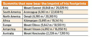
7 Summits Challenge
May 30, 2025↓News: Hyderabad teenager Vishwanath Karthikey Padakanti has become the youngest Indian and the second youngest person in the world to complete the legendary 7 Summits challenge. 7 Summits Challenge.

About 7 Summits Challenge
- The Seven Summits Challenge is a renowned mountaineering achievement that involves climbing the highest mountain on each of the seven continents.
- This challenge is considered one of the most prestigious feats in global mountaineering and is highly sought after by adventure climbers worldwide.
- Origin: The challenge was first proposed and completed by American mountaineer Richard Bass in 1985.
- Objective: To summit the highest peak on each continent—Asia, Africa, North America, South America, Antarctica, Europe, and Australia/Oceania.

Source – NIE - Major Lists: The Seven Summits challenge has two options –
- Bass (or Kosciuszko) List: Includes Mount Kosciuszko (Australia, 2,228 m) as the highest peak for the continent of Australia.
- Messner (or Carstensz) List: Includes Puncak Jaya (also known as Carstensz Pyramid, 4,884 m) in Indonesia as the highest for Oceania/Australasia, which some argue is more geographically accurate.
- Records:
- Kaamya Karthikeyan was the youngest Indian to scale the seven summits at the age of 17.
- The youngest person in the world to scale all seven peaks is American mountaineer Jordan Romero, who achieved the milestone at the age of 15.

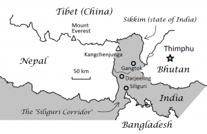
Mt. Khangchendzonga
May 30, 2025↓News: Sikkim Chief Minister has urged the Centre to ensure that Mt. Khangchendzonga, the world’s third-highest peak, regarded as sacred by the people of the State, is made out of bounds for mountaineers.
About Mt. Khangchendzonga

Source – Wikimedia - It lies in the eastern Himalayas, straddling the India–Nepal border, located between Sikkim (India) and Taplejung District (Nepal).
- Kangchenjunga is India’s highest (8,568 metres) and only 8,000+ meter peak.
- It is world’s third highest peak after Mt. Everest and K2.
- Meaning: Kanchenjunga or Kangchenzonga means “The Five Treasures of the Great Snow” in Sikkim because the mountain has five prominent peaks.
- They are Kanchenjunga Main (8,586m), Yalongkang (8,505m), Kanchenjunga West (8,420m) and Twin Peaks (both 8,476m).
- Unlike most other Himalayan peaks, this mountain runs from north to south, where the Kanchenjunga Glacier joins the Tamur River, a tributary of Koshi.
- Numerous lakes and glaciers, including the 26 km long Zemu Glacier, dot the barren high altitudes.
- World Heritage site: The Khangchendzonga National Park (KNP), Sikkim has been inscribed as India’s first “Mixed World Heritage Site” on UNESCO World Heritage List.
As a living deity
- The mountain is revered as the abode of the principal guardian and protector-deity of Sikkim, known as Dzoe-Nga.
- This sacred being is worshipped as the Pho-lha, or the chief of the entire assemblage of supernatural entities of Sikkim.
- These deities were recognised and anointed as the guardian deities of the land by Ugyen Guru Rinpoche, also known as Guru Padmasambhava, the Patron Saint of Sikkim.
Climbing ban in Sikkim
- The Sikkim government banned all climbing activities on Mt. Khangchendzonga through notifications in 1998 and 2001 under the Sacred Places of Worship (Special Provisions) Act, 1991.
- Sikkim’s ban on Mount Kangchenjunga’s summits aligns with Article 371F of the Indian Constitution, which safeguards Sikkim’s cultural and religious laws after it merged with India in 1975.
- In 1955, mountaineers Charles Band and Joe Brown became the first people to scale the peak but they stopped a few feet short of the Summit in honour of the Sikkimese belief.
Madden-Julian Oscillation (MJO)
May 28, 2025↓News: The southwest monsoon arrived early, reaching Kerala on May 24 and Mumbai by May 26 — the earliest ever. The IMD says this was mainly due to favourable weather patterns, especially the Madden–Julian Oscillation.

About Madden-Julian Oscillation (MJO)
- It is a tropical atmospheric phenomenon characterized by a moving system of winds, clouds, and pressure that brings rainfall as it moves eastward along the equator.
- It was discovered in 1971 by scientists Roland Madden and Paul Julian at the National Centre for Atmospheric Research in Boulder, Colorado.
- The MJO typically completes one global cycle in 30 to 60 days, although it can sometimes take up to 90 days.
- As it moves, the MJO creates two distinct zones — one where rainfall activity is enhanced (active phase) and another where rainfall is suppressed (suppressed phase).
- The MJO travels eastward at a speed of about 4 to 8 metres per second and primarily influences weather patterns in the tropical belt between 30°N and 30°S latitude, which includes India.
- The MJO has a significant impact on tropical weather systems, including monsoons, cyclones, and periods of heavy rainfall or dryness.
Phases and Impact of MJO
- During its active phase, the MJO leads to increased cloud formation, strong convection, and higher-than-average rainfall in the affected region.
- In its suppressed phase, the MJO inhibits convection and results in lower-than-average rainfall or dry conditions.
- These alternating phases occur periodically and can influence multiple weather events within a single season.

Bow Echo
May 28, 2025↓News: The intense storm that hit Delhi recently appeared in an unusual shape in the India Meteorological Department’s (IMD’s) weather radar imagery. The storm looked like a crescent or an archer’s bow. In technical terms, such presentations of storms are called “bow echoes”.
About Bow Echo

Source – IE - A bow echo is essentially a line of storms, also called a squall line, on the radar that looks like a bow.
- This squall line can sometimes be embedded in a larger squall line.
- Bow echoes are often associated with severe weather, including damaging straight-line winds.
- Naming: The term was coined in the 1970s by Ted Fujita, a Japanese American meteorologist known for developing the scale to classify tornadoes.
- Range: A bow echo can extend from 20 km to 100 km.
- Timeframe: It can last between three and six hours.
- Formation
- When rain-cooled air comes down to the ground, and spreads out horizontally, a boundary called the gust front is created between the rain-cooled air and warm-moist air on the surface.
- This front pushes up the warm-moist air into the atmosphere, which forms new thunderstorms.
- These new thunderstorms produce more rain, thereby creating more rain-cooled air, which helps the gust front to maintain its strength.
- As this process keeps repeating itself, there comes a point when there is an inflow of air on the trailing side of the line of storms and bends it like an archer’s bow.
- The cycle lasts as long as new thunderstorms keep forming at the front, helping the system grow and move forward with strong winds.
- Derecho: If the bow echo (or series of bow echoes) progresses more than 400 kilometers with widespread wind gusts 93 km/h or greater, then the bow echo is classified as a derecho.
- A bow echo is essentially a line of storms, also called a squall line, on the radar that looks like a bow.

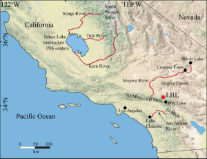
Tulare Lake
May 20, 2025↓News– Tulare Lake in California, which had vanished over a century ago, made a comeback in 2023 due to a series of intense atmospheric river events that swept across the state. Tulare Lake.
Key Facts about Tulare Lake:

Source – ResearchGate - Location: Situated in the San Joaquin Valley, California, USA.
- It was once recognized as the largest freshwater lake located west of the Mississippi River.
- It is replenished by the Kern River, which is fed by snowmelt from the southern Sierra Nevada.
- The lake disappeared as a result of human-induced irrigation activities.
- Indigenous Connection– The Tachi Yokut tribe historically depended on the lake.Its return has allowed the tribe to reconnect with their ancestral lands and traditions
Chandrayaan-5 mission
May 15, 2025↓News: The Chandrayaan-5 mission, jointly undertaken by ISRO and JAXA, was approved by the Indian Cabinet in March 2025. It aims to explore the Moon’s surface and subsurface for water. Preliminary design work for the lander and rover is now underway. Chandrayaan-5 mission

About Chandrayaan-5
Chandrayaan-5, also called LUPEX (Lunar Polar Exploration), this mission is a collaboration between ISRO and JAXA. It will carry a 6.5-tonne payload aboard Japan’s H3 rocket, scheduled for launch in 2027–28.
Mission Goals and Duration
- Water and Soil Exploration: The rover will trace water and drill into the Moon’s surface to study regolith samples.
- In-Situ Experiments: Instruments will assess water content, quality, and conduct surface analysis.
- Timeline: Planned for 100 days, with a possible one-year extension.
Scientific Collaboration and Technology
- ISRO’s Contribution: Developing the lander and one sensor in a large instrument with four sensors.
- JAXA’s Role: Building the 350-kg rover and three sensors in the same instrument. The rover will travel inclined surfaces up to 25° and has a complex battery charging system for sampling operations.
- Global Partnerships:
- ESA is developing a mass spectrometer.
- NASA is building neutron spectrometers.
- Both instruments are in the design phase.
- Total Payload: Seven scientific instruments will be onboard.
Background of Chandrayaan Missions
Chandrayaan-1 (2008): Mineral and chemical mapping.
Chandrayaan-2 (2019): 98% success.
Chandrayaan-3 (2023): Soft-landing on Moon’s south pole.
Chandrayaan-4 (Upcoming): Sample return mission.
Chandrayaan-5: Focused on deeper lunar exploration through international cooperation.
Strategic Significance
- Enhances India’s deep space exploration capacity.
- Strengthens Indo-Japan and global space partnerships.
- Supports future goals like India’s Bharatiya Space Station.

Dirang Geothermal Project
May 15, 2025↓News: The Centre for Earth Sciences and Himalayan Studies (CESHS) has successfully established the first geothermal production well in Northeast India at Dirang, located in the West Kameng district of Arunachal Pradesh. Dirang Geothermal Project

About Dirang Geothermal Project
- The first geothermal production well has been successfully drilled in Dirang, Arunachal Pradesh.
- The Dirang region is located within a medium to high enthalpy geothermal zone.
- With a temperature gradient of around 115°C, it is well-suited for efficient and low-impact geothermal drilling.
- Funding for the project is jointly provided by the Government of Arunachal Pradesh and the Ministry of Science and Earth Sciences, Government of India.
- The plant uses a closed-loop binary Organic Rankine Cycle (ORC) process to convert geothermal heat to electricity.
- Advanced geological, structural, and chemical analyses were conducted over two years prior to drilling.
- Drilling targeted a fault zone between quartzite and schist rock formations, ensuring efficient access and minimal environmental disturbance.
- Potential applications of geothermal energy include: Drying of agricultural produce (fruits, nuts, meat), space heating and controlled-environment storage
- These interventions are expected to significantly improve living conditions and agricultural productivity in high-altitude Himalayan areas.
About Geothermal Energy in India
- As per the Geothermal Atlas of India (2022), the country has 381 thermally anomalous sites and a generation potential of around 10,600 MW.
- India’s first geothermal project was in Manuguru, Telangana (20 kW pilot by SCCL).
- Puga Valley (Ladakh) and Khammam (Telangana) also have geothermal projects, though with varying progress.
- India has international collaborations in geothermal energy with Iceland, Saudi Arabia, and the USA under RETAP (2023).

Persian Gulf
May 9, 2025↓News– The US President Donald Trump plans to officially rename the ‘Persian Gulf’ as the ‘Arabian Gulf’ during a visit to Saudi Arabia, aligning with the preferences of Arab Gulf nations. Persian Gulf.
About Persian Gulf

Source- Worldatlas - Location– The Persian Gulf is a shallow marginal sea of the Indian Ocean, located in Western Asia, and bordered by several key Middle Eastern nations.
- It connects to the Arabian Sea through the Strait of Hormuz, a globally significant maritime route for oil transportation.
- The total coastline extends about 5,117 km, with Iran possessing the longest segment, roughly 1,536 km.
- Bordering Countries:
- North: Iran
- Southwest: Saudi Arabia, Qatar, United Arab Emirates
- Northwest: Iraq, Kuwait, Bahrain
- Key Islands: Qeshm Island (Iran): The largest island in the Persian Gulf, covering about 1,491 km²—nearly 2.5 times the land area of Bahrain.
- Strategic and Economic Significance
- The Persian Gulf plays a pivotal role in global energy dynamics, with nearly 30% of the world’s oil exports transiting through the Strait of Hormuz.
- The region frequently hosts naval deployments from powers such as the United States, Iran, and various Gulf nations, serving as a platform for military presence and geopolitical influence.

Kaleshwaram Lift Irrigation Project (KLIP)
May 6, 2025↓News- The National Dam Safety Authority (NDSA) reported substantial damage to the Kaleshwaram Lift Irrigation Project (KLIP) barrages following the 2023 flooding incident.
About Kaleshwaram Lift Irrigation Project (KLIP)

Source- Indian Express - It is a multi-purpose irrigation project located on the Godavari River in Kaleshwaram, Telangana.
- The Godavari River, often referred to as the ‘Dakshin Ganga‘, is the largest river in Peninsular India. It originates from the slopes of the Western Ghats in Maharashtra’s Nasik district, it eventually drains into the Bay of Bengal.
- KLIP is set to become the world’s largest multi-stage lift irrigation project.
- In lift irrigation projects, water is not transported by gravity from higher to lower elevations through canals. Instead, it is pumped or raised using surge pools to a main delivery chamber located at the highest point of the project, from where it is then distributed to the beneficiary fields.
- The project stretches approximately 500 km across 13 districts and includes a canal network spanning 1,800 km.
- It is a multi-purpose irrigation project located on the Godavari River in Kaleshwaram, Telangana.

Chenab River
May 6, 2025↓News– India has halted the flow of water from the Chenab River through the Baglihar Dam in Jammu and Kashmir. This move comes after the suspension of the Indus Waters Treaty following the Pahalgam terror attacks. Chenab River.

About Chenab river
Aspect Details Origin It is formed by the union of two headwaters, Chandra and Bhaga. These headwaters rise in the upper Himalayas in the Lahaul region of Himachal Pradesh, India Mouth It flows through the Jammu region of Jammu and Kashmir, then into the plains of Punjab, Pakistan, before ultimately flowing into the Indus River. Tributaries Right Bank: Marusudar (largest tributary), Miyar Nalla, Bhut Nalla, Bichleri, Ans, and Kalnai
Left Bank: Niru, Tawi, Neeru, and LiddrariMajor dams 1) Baglihar dam-near Ramban(Jammu & Kashmir)
2) Salal dam-near Reasi(Jammu & Kashmir)
3)Dul Hasti-near near Drabshalla in Kishtwar District
4)Pakal Dul Dam – a proposed dam on a tributary Marusadar River in Kishtwar District.NOTE-The Chenab river was called Asikni in the Rigveda.